- Mon 03 November 2003
- NewZealand
- Gaige B. Paulsen
- #travel
| Date: | 03.11.2003 |
| Start Location: | Lake Tekapo
S: 43° 59.873' E: 170° 27.663' Alt: 2492 ft |
| End Location: |
Mount Cook S: 43° 43.44 E: 170° 05.512' Alt: 2534 ft |
| Distance Driven | 143km (584km) |
Summary:
| Time: | 06:30 |
| Location: | Lake Tekapo |
| Name: | Rise & Post |
| Description: | |
|
After finally getting the Bluetooth and the phone to behave on Sunday night, I was now ready to upload the first portions of this web site. I hope that the viewing audience at home are enjoying it. After getting out of our respective bunks this morning, we each got to use the showers at the campsite. Although NZ$24 seems a bit pricey for hot showers, bathroom, water fill & dump and a power feed, the showers more than made up for it. Despite the cold morning air (the heater ran all night and barely was able to keep the van at 60°F), the showers were so hot that they required turning the knobs almost entirely to cool. After a quick breakfast at the "village" we took a few pictures and headed out to our morning drive.
|
|
| Time: |
09:20 |
| Location: | Lake Takapo |
| Name: | Around the lake |
| Description: | |
|
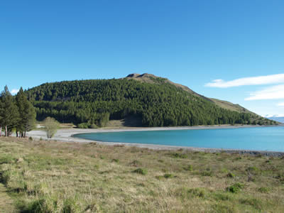
We started the morning's drive heading around the side of Lake Takapo. We had hoped to drive up to the observatory on Mt. John, but a private road sign barred the way and we decided instead to continue on the road around to Lake Alexandria. This lake is much smaller and feeds into Takapo via a small connecting stream and a minor lake. As we passed Alexandria, we encountered a sheep and cow farm which spanned the road (can you say cow grates). Mostly the sheep ran away at the first sound of our vehicle, while the cows remained charatersitically aloof. However, there were a couple of instances where we had to bring the van to a stop in order to let a lamb get its bearings and head back to follow mom. At times, the cows and sheep were even grazing together, conjuring thoughts of agricultural genetic expreiments — "Darn, son! That's a mighty big sheep there..."
And these sheep had a nice view as well.
|
|

| Time: | 11:30 |
| Location: | Godley Peaks Station |
| Name: | What is that thing? |
| Description: | |
|
We ended our travels around Lake Tapako at Godley Peaks Station before the one-lane wooden bridge being worked on by a pair of laid back Kiwis. After walking out on the bridge for pictures and to have a short chat, we walked back to the vehicle to turn around and head back to NZ8 for our trip to Mount Cook. Here's a question for the home audience: what is this?
|
|
| Time: | 13:00 |
| Location: | Mount Cook Visitor's Centre |
| Name: | Snowy peaks in the distance |
| Description: | |
|
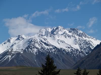
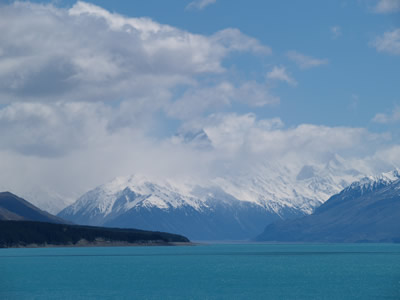
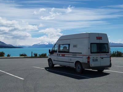
Once back on NZ8, we wound our way towards Lake Pukaki and the Mount Cook Visitor's Centre. This location looks down the lake back towards Mount Cook and the other peaks that make up the Southern Alps range.
For those curious souls amongst you, here's a picture of our camper van with the mountains in the background:
|
|
| Time: | 14:00 |
| Location: | Mount Cook |
| Name: | Lunch |
| Description: | |
|
At around 2pm, we rolled in to Mount Cook proper (location of the Visitor's Centre, the Hermitage hotel and a number of other establishments). After a quick browse at the Visitor's Centre to acquire trail maps (and gloves, as the temperature had dropped precipitously since our departure in the morning) we then headed over to the Mountaineers Cafe for lunch. This relatively new building is very stylish (including plenty of low voltage spot and mood lights) and served some pretty high quality food. (Of interest later will be the prediction for snow around 900m and 80km/h winds). |
|
| Time: | 15:00 |
| Location: | Mount Cook |
| Name: | Hooker Valley Hike |
| Description: | |
|
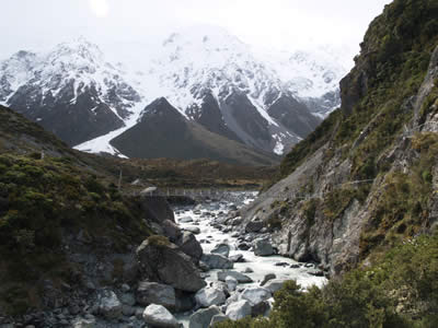
From lunch, we headed to the White Horse Camp Sites to find someplace to park the camper van and to take our first hike of the day, Hooker Valley. The Hooker Valley hike took us past the Alpine Memorial (in memory of those who have lost their lives climbing in the Southern Alps) and then over a pair of swinging bridges as it wound its way along the river in a scenic tour of the glaciers. Due to a brain fart on my part, about half of the pictures I took on this section were not worth posting, but we did see some interesting snow dancing near the peaks of the mountains and had some nice views of the glaciers, moraines, and other features until the snow started coming in.
By the time we crossed the second swinging bridge, we were ready to give up and go back to camp. At this time, the winds were certainly howling and snow was blowing harder as the time went on and so we decided to head back to camp. |
|
| Time: | 18:20 |
| Location: | White Horse Camp Grounds |
| Name: | Down for the count |
| Description: | |
| After a nice day of driving and hiking, we headed back to the van for a peaceful night sleep. This was a great day (even if the weather didn't completely cooperate) and we're all a bit tired. | |