- Sun 02 November 2003
- NewZealand
- Gaige B. Paulsen
- #travel
| Date: | 02.11.2003 |
| Start Location: |
Rakaia River Mouth S: 43° 54.179' E: 172° 11.663' |
| End Location: | Lake Tekapo
S: 43° 59.873' E: 170° 27.663' Alt: 2492 ft |
| Distance Driven | 188km (441km) |
Summary:
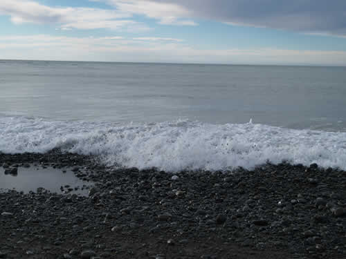
| Time: | 07:00 |
| Location: | Mouth of the Rakaia River |
| Name: | Sunrise walk |
| Description: | |
|
Unlike the sunset last night, the sunrise this morning (actually occuring some time before our walk) was not very picturesque. The lighting and cloud conditions were such that very little of the sunrise was available to the camera lens (or eye). However, after getting out of the bunks, we headed up the beach to look for the mouth of the river itself. The walk was surprisingly long (covering between 3-5km) and took place mostly on the loose gravel that defined the line between the ocean and the river. We did make some nice pictures at the mouth itself, where "dancing stones" were pushed onto the shore by incoming waves.
On the way back, we were being stalked by some kind of dolphin in the ocean. |
|
| Time: | 09:00 |
| Location: | Raikaia |
| Name: | Sunday morning shopping spree |
| Description: | |
|
It's sunday morning and we find ourselves once again doing that which neither of us enjoy, shopping. This mornings order of business is all of the stuff that we forgot the last time, including a ton of batteries, then it is off to the grocery and finally a stop for brunch. |
|
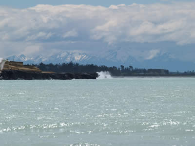
| Time: | 12:30 |
| Location: | Timaru |
| Name: | Crashing waves, hidden mountains |
| Description: | |
|
About lunch time we stopped in Timaru (a town along the sea cost near NZ1 and NZ8) at their public park near the docks. Although the looming containers gave the entire setting a bit of a surreal look, there was a point in the distance where the ocean was crashing in and it gave me a great chance to use the 200mm lens. Fortunately, with a lot of sunlight, my lack of steadiness was helped by the camera being able to nicely shoot at 1/800.
|
|
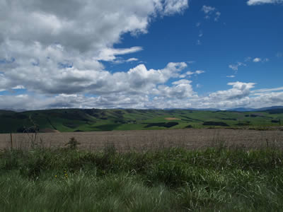
| Time: | 14:30 |
| Location: |
Between Timaru and Cave S: 44° 20.679' E: 171° 04.425' |
| Name: | These sheep have a great view |
| Description: | |
|
While driving along a gravel road trying to find our way to NZ8, we passsed by this farm, with astounding colors in the background. The sky above was a mix of overcast and bright blue, while the land below was a contrast in stark brown furrows and lush green "lawns" (it's hard to call anything that well groomed a meadow). We stopped and shot some pictures before resuming our trek along NZ8 toward Lake Tekapo.
|
|
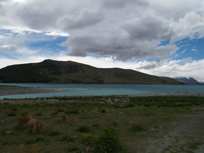
| Time: | 16:00 |
| Location: | Lake Tekapo |
| Name: | Blue watered mountains |
| Description: | |
|
After another hour or so on the road, we arrived at lake Tekapo. From the road, it sneaks up on you as the lake is nearly completely hidden by hills or mountains on every side. The altitude is about 750m here, so it is quite a bit cooler than down at the coast, making jackets a good idea.
The town is clearly a tourist-oriented endeavor, with a half-dozen restaurants, a small grocery and a few souveneir shops dotted with the obligatory tour companies. There are a couple of hikes out of the area and the lake itself is quite pretty. Walking around the town, we discovered that the lake itself appears to be at least partially man-made, as there is a dam at one end. Further, the campsite is near a water intake for a hydro facility, although based on the amount of visible concrete, I'm guessing that the water levels are down quite a bit from what they would like at this time. However, it is still pretty early in the season, perhaps there is more runoff to come. |
|